15 Best Hiking Trails in the UK
Picking your best walking in the UK is a difficult process. It's difficult to choose favorites because everyone has their own favorites, but we did our best to select the best 15 walking routes in the UK that everyone will find special.

Monsal Path, Derbyshire
Route: Blackwell Mill, Chee Dale to Coombs Road, Bakewell
Numerous natural gems, such as caves and ethereal gritstone rock formations, may be found in the Peak District National Park. The Monsal Trail follows an old railroad bed that was in operation from 1863 to 1968, it's part of a more recent landscape modification. Before coming into alignment with the River Wye, the route winds through the peaceful farmland near Bakewell's old station and then dips through six (well-lit) tunnels, providing occasional glimpses of the verdant valley. Bicyclists like the flat, broad path, while wheelchair users will appreciate the convenient access spots.
Exploratory Glory YouTube Channel
South Downs Way
Route: Ridges and chalk escarpment of the South Downs
Along the chalk cliffs and hills of the South Downs, the South Downs Way National Trail travels for 100 miles (160 kilometers) and follows the original paths and driveways that were there before. The path offers visitors the chance to "get away from it all" without having to go too far in this bustling region of England by taking advantage of the option presented by the route. Both walkers and long-distance riders will enjoy the undulating path due to its beautiful scenery and challenging terrain. In addition to that, it offers a variety of intriguing day excursions and short holidays.

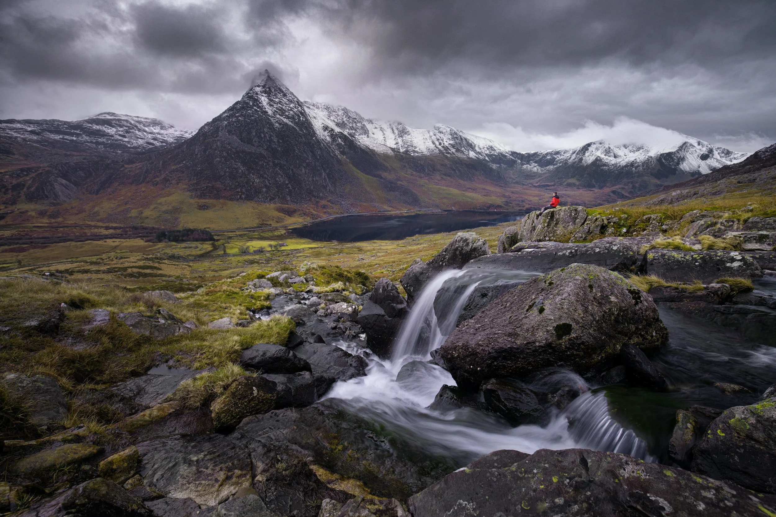
Snowdon Traverse, Gwynedd
Route: Pyg Track west from Pen-y-pass to Rhyd-Ddu
Since 1896, you may take a train to the top of Wales' tallest peak, Mount Snowdon, making the mostly parallel Llanberis Path a somewhat monotonous method to reach the peak. If you make use of the mountain train and the local Snowdon Sherpa bus, you may take two days to complete the climb and descending of Yr Wyddfa/Snowdon without having to retrace your steps. One possible route begins from Pen-y-Pass and follows the Miners' Track into a bowl of mountain lakes before dropping down the Rhyd-Ddu Path the following day.
Glomach Waterfalls, Ross-shire
Route: Morvich
As the UK's highest waterfall, the Falls of Glomach has the greatest vertical drop of any waterfall in the country. Despite their depth-charging, gravity-gushing drop, they are surprisingly easy to notice, prompting some to dub them the "hidden" falls. A key factor in their ability to vanish is their location, high up in a tight canyon in the middle of nowhere in the Scottish highlands. The spray from the waterfall itself adds to the obscurity, shrouding the entire picture in a moist cloak of mist and mystery. Begin and end at the Forestry parking lot close to Morvich. You'll reach wild highland landscapes after a short ascent through the forest. The trail is clearly defined, but you should prepare for any weather.

Snowdonia National Park
Route: Snowdon via the Pyg Track
The route of Snowdon through this seven-mile path is not for the faint of heart! This route, which follows the slopes of Crib Goch, is the most difficult and treacherous of the six ways that may be taken to the summit of Snowdon. It is not recommended for inexperienced hikers to attempt climbing Crib Goch or walking along the ridge because both of these routes are exceedingly hazardous. It takes about six hours to complete.
John Muir Way, Scotland
Route: Helensburgh to Edinburgh
This coast-to-coast path offers a window not just into Scotland's historic terrain, but also into its industrial history and urban present, and while it may lack the drama of the wild and tough Cape Wrath Trail, and some seasoned Scottish trekkers may be shocked that its high point is only 401 meters, it accomplishes something else. John Muir, a pioneer of Yosemite National Park, spent his early years in Dunbar, the trail's eastern end.
The walk is divided into ten sections, each of which may be completed in a single day. Early parts, beginning at Helensburgh on the Firth of Clyde, cross moors and forest and circle magnificent Loch Lomond; later stretches include canals, astonishing castles, modest fishing towns, boat-shifting Falkirk Wheel, and Edinburgh. Its excellent website lists pubs and B&Bs along the route, and each segment is well-marked and accessible by public transportation.

Brecon Beacons National Park
Route: Beacons Way
The Monmouthshire and Brecon Canal and the ruins of Llanthony Abbey are just two examples of the stunning landscape that can be seen along the 95-mile Beacons Way. Other tough summits along the route are Pen y Fan (886m) and Corn Du (873m). It then goes on into the Western Beacons, which are a little less well-known but just as stunning. The hike is broken up into eight distinct segments, each of which takes a full day to accomplish.
Tideway Thames, London
Route: River Thames to Limehouse
Once the Thames River reaches London, it quickly succumbs to the sea. The latter sections of the Thames Path provide a city walk of comparable scope to hikes in national parks, with famous sites like the Tower Bridge and Houses of Parliament served up with abundant urban greenery. The tidal nature of the Thames is established at Teddington Lock. The route then branches off, offering the option of continuing along the north bank or the south bank (with various crossing points along the way).

Lake District National Park
Route: Back Trail via the Jenkin Hill bridleway
A new 20-mile trail, known as the Ullswater Way, surrounds what many people consider to be England's most picturesque lake. It links the attractive villages and attractions to the breathtaking landscape that runs down the coasts of Ullswater, allowing tourists to enjoy even more of this unique part of the Lake District. Because the Ullswater steamer runs in both directions, you may walk a portion of the trail and then take the boat back.
The South West Coast Path
Route: Minehead in Somerset to Poole in Dorset
The South West Coast Path is one of the world's top five most breathtaking trails, with the Milford Track in New Zealand, the Torres del Paine journey in Chile, and the Chilkoot Trail in Alaska.
The South West Coast Path is one of just 12 treks in the world to be featured in the highly regarded guidebook, and it is the only hike in the United Kingdom to do so. From Minehead in Somerset to Poole in Dorset, the 630-mile Coast Path is the hike of a lifetime for those who are up for the challenge.

Yorkshire Dales National Park
Route: North-east of Manchester to the south
Lower Wensleydale is home to the breathtaking Aysgarth Falls, which is located along a length of water. The movie Robin Hood: Prince of Thieves was released in 1991, and it features the tree-lined River Ure as it plunges over a series of three waterfalls. The path leads you through a nearby wildlife preserve that is home to roe deer, dormice, and red squirrels. It is an approachable path that is appropriate for individuals who are less mobile as well as families with strollers.
Somerset's Holnicote Estate
Route: Allerford to Bossington Beach
To see the wild coast and heather-covered uplands in the eastern part of Exmoor National Park, walk in a figure-of-eight pattern from the village of Allerford, primarily around the Holnicote Estate, which is owned by the National Trust. The northern loop of the first day takes you up Selworthy Beacon for a view of the Bristol Channel and then down to Bossington Beach. Dunkery Beacon, at 519 meters above sea level, is the highest point in Exmoor and can be reached via a longer and steeper southern loop that passes through the ancient oak forest of Horner Wood. Herds of hardy Exmoor ponies, grazing in a semi-wild state, may cross your path.

Jurassic Coast, Dorset
Route: Lulworth Cove to Lyme Regis
The complete length of the Jurassic Coast, which includes the area west of Exmouth in Devon, is close to 100 miles. The South West Coast Path section between Lulworth Cove and Lyme Regis, where the Jurassic Coast's most famous attractions are located, is the focus of National Trails' recommended seven-day hike, managed by Footscape. When you look along the length of the Fleet, a lagoon enclosed by 18 miles of Chesil Beach, or consider the forces that sculpted the limestone arch of Durdle Door, you may be reminded of geography lectures from long ago.
After exploring the stunning landscapes and geological wonders of the
Jurassic Coast, travelers can unwind and immerse themselves in the charm of
countryside living by staying in cozy English cottages.
Hadrian’s Wall Path
Route: Wallsend, Newcastle to Bowness-on-Solway, Cumbria
The Hadrian's Wall Path is a National Trail that stretches over 135 kilometers (84 miles) through northern England, beginning in Wallsend, Newcastle upon Tyne, and ending in Bowness-on-Solway, Cumbria.
Following the path of the Hadrian's Wall World Heritage Site, the National Trail travels through some of England's most picturesque landscapes, including towns and cities like Newcastle and Carlisle, and dozens of interesting museums.
The Hadrian's Wall Path is accessible to anyone in generally good physical shape. The most challenging terrain is found over the 37-kilometer (23-mile) stretch between Chollerford and Birdoswald.
The Path is well-defined, and you may choose to follow it in the direction in which the wall was originally constructed or the way that is advised for better weather circumstances.
Hadrian's Wall Path is best hiked between May and October when the weather is more stable and the Trail is less likely to be muddy from the rain. In the summer, especially in the months of July and August, the Trail and Hadrian's Wall attract many visitors.

Cotswold Way
Route: Chipping Campden to Bath
The path travels through undulating grasslands, beech woods, and honey-colored Cotswold stone cottages.
You'll see Neolithic burial barrows, elegant houses, and historic war sites. The Cotswold escarpment trail offers ever-changing vistas of the River Severn and Malvern Hills.
Anyone in reasonable shape may walk the Cotswold Way, although many are startled by the severe slopes. Following the National trail is easy because it's well-marked. A guidebook or map is usually helpful.
The Cotswold Way is walkable year-round. Crisp winter days, autumn, and spring may be the finest time to explore the Cotswold escarpment. Spring and October are the finest times to observe meadows and beech woods.